
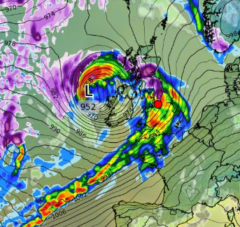
A storm is currently in the Atlantic and heading for the UK, on weather maps its heading directly towards Manchester.
Weather forecasters are split on how far north the storm will get on Friday however according to WXCharts the storm is coming straight for us which will see very strong gusts of wind for much of the day.
The amount of rain dumped on North West as well as Manchester will likely lead to flooding in some areas, if the storm sticks around for even an hour we expect very high river levels and brooks will flood.
On Saturday the winds will ease and for many places it is predicted to be a dry day with no rain for Manchester until later in the day where some places will have showers.
Sunday will be the better day to get out and about during the morning and afternoon with lighter winds and dry, during early evening though low pressure comes in and another storm comes in which will see high winds and lots of rain, this will continue for the night and for Monday.
Much of the damaging wind gusts will mostly hit the Midlands and the South however we will also see some strong winds and lots of rain throughout the day.
It will be a mixed bag from next Tuesday and Wednesday with many showers some of which will be heavy in some areas.
Next weekend at this time looks like Saturday is the best day to get out and about and Sunday a line of heaving showers can be seen during the afternoon, although largely a dry day and no wind.
Discover more from
Subscribe to get the latest posts sent to your email.
